Elk Cove and More
My vacation is winding down, so I really wanted a wilderness experience. As I get older, I seem to have fewer and fewer of them, and that’s a shame. I’ve got a lot of irons in the fire, but yesterday I sought to rectify that absence and headed to the north side of the highest mountain in Oregon. The drive is long but the hike is shorter and easier than many approaches.
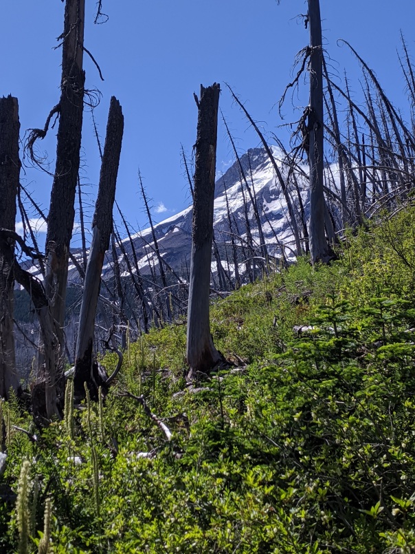
From the Vista Ridge Trailhead, the trail goes through half a mile of typical Cascade forest, then emerges into a charred landscape left over from the Dollar Lake fire in 2011. The underbrush is thriving, but here are few trees left alive over ten feet tall. Lots of silvery trunks make for an odd atmosphere, but I find it fascinating. Once I climbed out of that in a couple miles, the wildflowers started dotting the sides of the trail. I’d worried I was late, but not at all. Once I hit the Timberline Trail, I had a quick decision to make about finding a campsite. I chose to seek a new spot in Elk Cove, a big open meadow below the steep slopes of Mount Hood abutted by the massive talus slopes of Barrett Spur.


Once I made camp, I snacked and headed out on a hike to points east. Three stream crossings later, a couple of which are tricky, I made it to a nice set of rocky slabs above Compass Creek Falls. It’s hard to get a straight-on view of the falls, because it’s below the trail. I found a nice flat rock and napped briefly in the sunshine. Sleeping in the sun feels like vacation.
The flowers along the trail kept surprising me. Yellow, lavender, red, white, pink, orange. It’s such a treat to catch the mountainsides bedecked in coat of many colors. My walk back to camp was uneventful other than starting to see a lot more people. It was a good day.


My only disappointment was when I realized my camp was too far in the shadow of a massive ridge to see the comet Neowise, but that was a small price to pay for the lovely vista I had while eating a mediocre freeze dried dinner. An early evening ramble along a user path in the meadows let me see a different perspective of creek and flowers and mountain above. I took a series of photos and eventually wandered back to my tent feeling intoxicated by the beauty of the area.
I woke early today and headed out, knowing I had business to attend to at home, but also knowing my legs might not be up for another side trek. I am already thinking about my next visit to the area.
Dry Creek Falls
Hello! It’s been a minute. Or two years, but hey, who counts? I have been spending more time on Instagram as I’ve been trying to really learn photography. Check it out if you like. @joshbakerwriter. So it may seem a bit ironic that I am back on the blog using only cell phone shots. Ha ha. Life is funny. My wife and I spent some time out in the Columbia River Gorge this week. There are so many pretty places out there. Due to Covid-19 restrictions, many popular trails are closed, but we still found some great spots.
Dry Creek Falls is roughly a 4.5 mile round trip hike from Cascade Locks. The forest shows signs of the Eagle Creek Fire in the first half, yet it still manages to be green in both the canopy and the ground cover. The slopes are steep but the trail is not. This is an easy hike for the two miles or so to the small babbling brook that is Dry Creek. The falls are a few hundred yard up a side trail. Yes, it’s worth it.
If you are looking for additional exercise opportunities in the area, consider a walk around Blackberry Beach or a ride on the nearby mountain bike trails. One could also put in their kiteboard on the Columbia there. Whatever your flavor, Cascade Locks probably has it. Have fun out there, and stay safe.


a
Still Out There
I am still hiking, dreaming, taking more photos, working on my writing, and just plain working, way too much as it turns out. My bones are feeling old. Still, I get out in nature when I can and try to do cool stuff. I made a website this year, although I’m already proving myself shoddy at maintaining it. Check it out if you are interested. I promise there are some pretty pictures along with links to some of my published writing.
Chasing Snow, Finding Fog
 Having lived in the mountains for years, I am accustomed to dealing with cold, rain, and snow. That said, as a city dweller now, I play it cautious because I’ve learned not to trust other drivers. When the Portland area got its first snow freakout warning of the season, however, I decided it would be a nice opportunity to take a hike in different conditions. Luckily, the roads were simply wet on the way to Marquam Nature Park. Good start.


I left my vehicle in one of numerous pullouts along Terwilliger Boulevard and headed up the muddy Marquam Trail. I had no particular place to go, I just wanted to gain elevation and hopefully see a little snow. Ultimately, I created a loop with the Flicker and Towhee Trails. My route trended upward for a while, and then flattened out in a quiet forest. I topped out at less than 800 feet above sea level. There were dustings of snow here and there, and I did see a few flakes falling. The slick mud underfoot affected me more than any white stuff.

A moody look up this steep foggy hillside
While Marquam is not a well known as its big brother to the north, Forest Park, it is also sizable and a fine choice for any Portland area hiker or jogger in need of a few trail miles, even when a touch of snow is in the forecast. Happy trails.
Forest Green River Scene
Amid a lot of literal and figurative cloudy weather, I found the perfect golden window other day for a walk. Nothing like leg stretching and photography experiments in the sun to make me feel better about the world. Okay, a mountain top would beat it, but hey. Rocks, moss, leaves, a passing seaplane, wings of a dove, er, seagull, and my boy Jackie Chan. Seeing him cut loose on a beach would prompt a smile from the biggest curmudgeon. All is right with the world. Well, mostly.


Willamette Shoreline Stroll
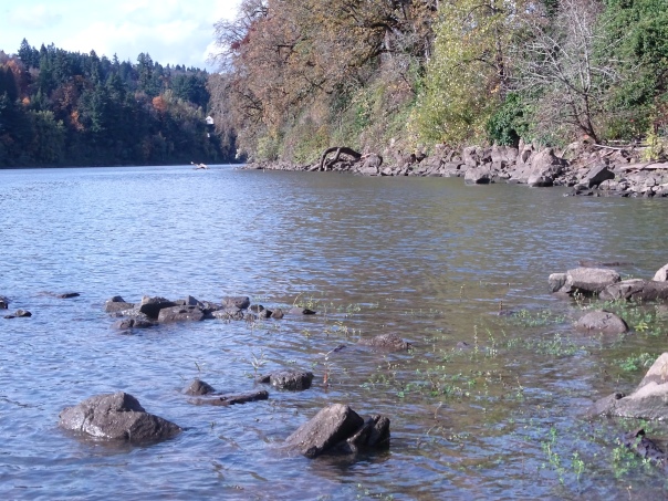 In the middle of a stretch of long days at work, it was nice to take a riverside walk with Denise and Jackie Chan the other day. It was another chance to play with my new camera as well. The weather was terrific, and we lucked out seeing a great blue heron as well as other waterbirds. The water level has risen with autumn rains, and the Willamette’s shore is very rocky, so we had to pick our path with care. We didn’t go far, but a short trip in nature is always a good thing. Happy trails.


Kellogg Lake ‘Vestigation
In the Baker family, when one wants to check out an area with which we are not familiar, we say that we are “‘vestigating.” A gray Sunday seemed like the perfect time for such an outdoor ‘vestigation that offered possibilities for photographic endeavors. My new Sony DSC HX400v was calling my name, as I am still less than adept at its various controls and menus. My friend Hamid was game for a hike, and he knows more about photography than me. Winning!
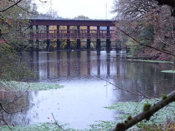
Kellogg Lake is a major geographical feature in the Milwaukie area, yet few people see it unless they live in certain spots or ride the light rail train, which crosses the outlet from an elevated perspective. Elsewhere, it is hard to view the water. A modest trail network descends a hillside behind the Presbyterian Church. I’d heard of this but had no good information. So Hamid and I explored, trying first this route and then that. There is plenty of walking to be had for a small area, spur trails going out both sides of a small peninsula, where we checked out waterbirds, foliage, and views across the lake. We kept spooking an egret who was close to us on a few occasions. I was never fast enough on the shutter to catch it in flight, but I did find it from afar. Magnificent bird.
Rain started coming down in earnest after we hit the far end of the lake, and although we saw a heron and enjoyed the different vantage points, there was less to explore there, so we adjourned to the Beer Store Milwaukie, which is also a restaurant and bottle shop. I opted for Ninkasi’s seasonal ale, Sleigh’r. Hamid got a stout. It’s tough to go wrong with 15 rotating taps. We enjoyed lots of interesting conversation about art, music, friends, and the circuitous paths our lives had taken, topping off a very pleasant afternoon.
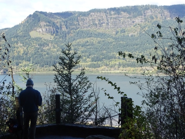
Columbia River Gorge Tour #2
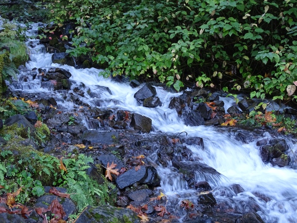
The creek below Wahkeena Falls
Initially, Denise and I headed for Latourell Falls. The sky was foggy, the temperature cool, so I was not overly excited, but I wanted to stretch my legs and take some photos with my new camera. Once we got on the scenic highway at Corbett, plans evolved. We stopped at first great viewpoint, known as the Portland Women’s Forum Viewpoint. Not a bad seat in the joint. I’d never been to the far end to the parking lot before, with slightly better views of the river and a classic look at Crown Point. From there, we drove to the nearby Vista House atop Crown Point, then dropped into the trees on the winding road to the first big falls of the Gorge.


For a few reasons, we didn’t set out on a real hike at Latourell Falls, which I’ve previously documented on this site. Instead, we strode up the first steep pitch to a nice viewpoint of the falls, then turned back. I was thinking Shepperd’s Dell would be our next spot, but I forgot all about Bridal Veil Falls State Park! Silly me. It isn’t dramatic from the road, but this is a hidden gem with two very different trails. Since Denise had not seen the river overlook trail, we skipped the waterfall trail and ambled about the meandering flat trail. There are views of the mighty Columbia in both directions, and great head-on looks at the Washington side of the Gorge in the Cape Horn area.


Shepherd’s Dell is not much of a spot to hike, but it has a cool falls, which is made more mysterious by upper reaches I’d never before noticed. The watercourse almost corkscrews. Cascades are visible through the trees along the highway which are invisible from the trail itself. This is a great little spot for a rest.

Wahkeena Falls
Like its big brother Multnomah Falls, Wahkeena Falls is a popular spot, and with good reason. The falls is not one clean plunge, but a couple of horsetails and a cascade below to boot. The base of the main falls is easily accessible by paved trail.

Fern gully
Knowing this, we cruised up there. It only takes a few minutes. I was impressed by the flow and the breeze which that created. I didn’t dally long by the falls proper, but continued past. We hiked up about 11 switchbacks to Lemmon Viewpoint, which took perhaps 20 minutes. I didn’t remember how tough the trail was, but it was easy, and the views were great. It was a nice capper to another great tour of the Columbia River Gorge.
Lemmon Viewpoint and Washington
Note: In double checking spellings of a couple waterfalls, I stumbled on a cool site for waterfall lovers, Northwest Waterfall Survey. I knew a number of the names, like Ecola and Mist, but was not aware of Dalton, Little Necktie, and a few others. Just when I needed new ideas for local exploration! Happy hikes, everyone.

East to Beacon Rock
Misty Moody Mountains
They’re not actually called the Misty Moody Mountains, but the description fit on a gray day above Whittier. The rain came early and stopped. My regular trail pants got soaked from brushing against dripping trailside bushes, and made me wish I had my rain paints. Oh well. The trail did not get close to the waterfall I was attempting to spy up close, but the hike was beautiful anyway. Don’t you agree?


Gray Green Beautiful Scene
Alaska is large. Who knew? It felt like it was going to take a looong time to get from Talkeetna to Whittier, where we would go on the half day glacier cruise the next day. And so it did, but we saw some cool stuff along the way. We took a detour up Hatcher Pass, which is known for some historic mining buildings. It turned out to be a long detour–a long, beautiful detour with territory ripe for exploration. We didn’t exactly hike a lot, but the potential is off the charts, especially as we gained elevation. Such gorgeous, open country. I kept wanting to make comparisons to other places, but they fall short. Alaska is its own world.


The mountains and valleys we saw on that detour are but a mere wrinkle in the landscape of Alaska. And there’s more. Lots more. The weather wasn’t great, so we didn’t stop much more until we passed Anchorage. Once we were driving along the water, we started looking for whales, specifically Belugas. No luck. That’s okay. It was still a cool part of the Alaska experience. More to come.


